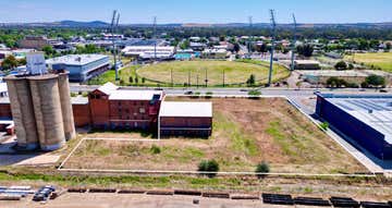
5 Dangar Place,
Wagga Wagga, NSW 2650
Development Sites & Land
Key property information
Land area
Property extent
Sold on
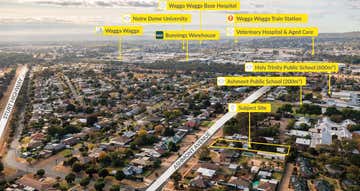
Map of 5 Dangar Place
Positioned Between the City and Forest Hill
Located:
Dangar Place is found off Edison Road, located on the eastern fringe of the City mid way between the main City Centre and Forest Hill township and Wagga Wagga airport
Access to Edison Road is along Tasman Road or Bakers Lane off the Sturt
Highway (Hammond Avenue.)
Area:
Approximate area of 5,518 square metres.
Zoning:
IN1 - General Industrial
Improvements:
- access off Edison Road
- positioned between the City and Forest Hill
- flood free as noted on WWCC flood plan (subject to council confirmation)
Price:
Contact Agent
Disclaimer
All areas and figures approximate only. All precautions have been taken to establish the accuracy of the above information, but does not constitute any representation by the Agent of Vendor. All of the information contained in this document is from sources the Agent and Vendor believe to be reliable; however, we cannot guarantee its accuracy. Prospective purchasers are advised to carry out their own investigations.
Wagga Wagga, 2650 demographic data
The median household income for Wagga Wagga is $1,355, 6% lower than Regional New South Wales's household income of $1,434. Wagga Wagga has a younger age profile compared to the rest of Regional New South Wales (median age 38 vs 43). Property ownership data shows 36% of property owners in Wagga Wagga have a mortgage.
7,198
Population
$1,355 per week
Median household income
38 years
Median age
Renters
Most residents
Families
Most households
5 Dangar Place
Wagga Wagga, NSW 2650

Fitzpatricks Real Estate138 Baylis St
WAGGA WAGGA, NSW 2650
WAGGA WAGGA, NSW 2650
Similar properties
Other properties you might be interested in based on the location and property type you are looking at.


Contact Agent
50 Edward Street,Wagga Wagga, NSW 2650 33256 m²Development Sites & Land • Shops & Retail