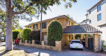
235 Burns Bay Road,
Lane Cove West, NSW 2066
Development Sites & Land
Key property information
Land area
Zoning
Sold on
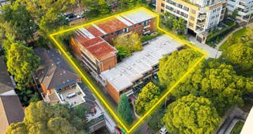
Map of 235 Burns Bay Road
Prominent, Main Road Development Site
Rare development opportunity on north shore arterial road
Prominent, highly trafficked position near the intersection of Burns Bay Road and Penrose Street
Flexible B1 Neighbourhood zoning allowing a range of uses (STCA)
Land area of 697sqm*
Frontage of 23m* to Burns Bay Road
Expressions of Interest closing at 1:00pm Monday 19th October 2015 (AEDT)
Prominent, highly trafficked position near the intersection of Burns Bay Road and Penrose Street
Flexible B1 Neighbourhood zoning allowing a range of uses (STCA)
Land area of 697sqm*
Frontage of 23m* to Burns Bay Road
Expressions of Interest closing at 1:00pm Monday 19th October 2015 (AEDT)
Lane Cove West, 2066 demographic data
The median household income for Lane Cove West is $2,966, 43% higher than Greater Sydney's household income of $2,077. Lane Cove West has a similar age profile compared to the rest of Greater Sydney (median age 37). Property ownership data shows 53% of property owners in Lane Cove West have a mortgage.
3,146
Population
$2,966 per week
Median household income
37 years
Median age
Owners
Most residents
Families
Most households
02 9254 99...
235 Burns Bay Road
Lane Cove West, NSW 2066

Stonebridge Property Group - SydneyLevel 7, 14 Martin Place
SYDNEY, NSW 2000
SYDNEY, NSW 2000
Contact Agency
Similar properties
Other properties you might be interested in based on the location and property type you are looking at.