1 Mavis Street,
Revesby, NSW 2212
Development Sites & Land
Key property information
Land area
Floor area
Zoning
Map of 1 Mavis Street
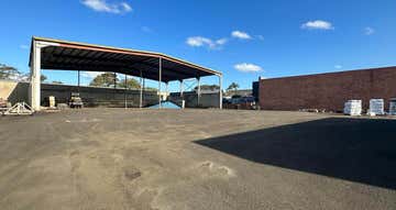
CLEAR FENCED YARD
- 4a Industrial zoned land
- Regular shape yard 40 x 40 metres
- Level clear and secure
- 2 gate access
- 50 metres from Canterbury Road & 500 metres to M5 on ramp
- Regular shape yard 40 x 40 metres
- Level clear and secure
- 2 gate access
- 50 metres from Canterbury Road & 500 metres to M5 on ramp
Revesby, 2212 demographic data
The median household income for Revesby is $1,844, 11% lower than Greater Sydney's household income of $2,077. Revesby has an older age profile compared to the rest of Greater Sydney (median age 38 vs 37). Property ownership data shows 51% of property owners in Revesby have a mortgage.
15,268
Population
$1,844 per week
Median household income
38 years
Median age
Owners
Most residents
Families
Most households
0490 083 7...
1 Mavis Street
Revesby, NSW 2212

Commercial Property Group - South West SydneyLevel 3, 56 Kitchener Pde
BANKSTOWN, NSW 2200
BANKSTOWN, NSW 2200
Similar properties
Other properties you might be interested in based on the location and property type you are looking at.

Contact Agent
17 Fitzpatrick Street,Revesby, NSW 2212 770 - 3827 m²Development Sites & Land • Warehouse, Factory & Industrial • Showrooms & Large Format Retail
Contact Agent
128 Milperra Road,Revesby, NSW 2212 1070 m²Warehouse, Factory & Industrial • Development Sites & Land • Showrooms & Large Format Retail
Contact Agent
106-110 Belmore Road,Riverwood, NSW 2210 1115 m²Warehouse, Factory & Industrial • Development Sites & Land • Showrooms & Large Format Retail